Kml Map Data
KML Map Server v.0.5
KMLMapServer turns any UMN MapServer installation in a flexible KML vector and raster data server.
AnyChart Flash Map Converter v.1.0.4
Convert ESRI ShapeFiles (.SHP) geolocation data into AnyMap format to be used with AnyChart. AnyChart Flash Map Converter allows making use of a wide choice of maps with AnyChart, a GIS system that recognizes map data in AnyMap format only.
GenGIS v.1 8
GenGIS is a bioinformatics application that allows users to combine digital map data with information about biological sequences collected from the environment.
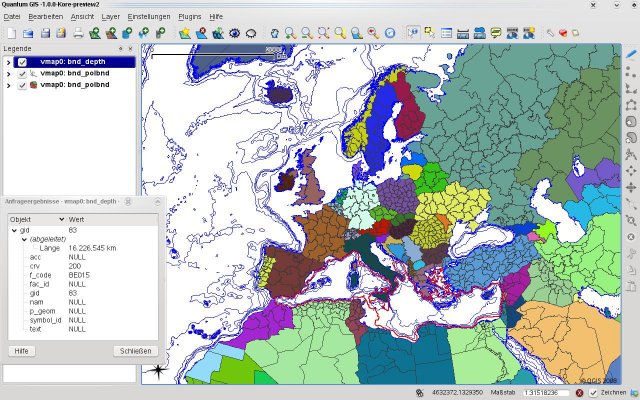
Quantum GIS form Mac v.1.8.0
QGIS supports vector, raster, and database formats and lets you browse and create map data on your computer.
USAPhotoMaps v.0.2.7.8
USAPhotoMaps downloads aerial photo and topo map data from Microsoft's free TerraServer Web site, saves it on your hard drive, and creates seamless maps from it.
KWare DigiMap v.1.21.0328
DigiMap is a graphical program for simple digitization of map data to create ASCI files of ordered x,y,z triplets. It is a quick and easy alternative to expensive digitizing tablets and software.
TatukGIS Viewer v.2.9.0.5307
TatukGIS Viewer opens most GIS/CAD vector, raster image, and grid file types, including the aerial imagery and vector street map data provided by the leading vendors, most ArcView, ArcExplorer, and MapInfo projects,
SMAPedit v.0.9 Beta
Simple MAP editor. sMAPedit is a easy-to-use MAP editor. It is an easy-to-use MAP editor. sMAPedit Features: 1. converts map data from client to server 2. can edit various server map files 3. included a html viewer for exploreing the world map.Using
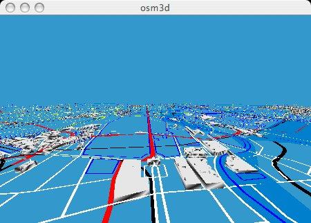
Osm3d v.0.02
This is Osm3d - a software to display 'Open Street Map' data in 3d - for Linux and MacOS X.
AnyChart Map Converter v.1.0.3261.26913
Visualize geolocation data in ESRI ShapeFiles format. AnyChart Map Converter utility is designed to convert ESRI ShapeFiles (*.shp) into the special AMAP format for using in the geo map module of AnyChart Flash Component - AnyMap.
GeoVisu v.5.0.1
GeoVisu is a program that displays georeferenced data (images, graphics) and downloads data recorded by some GPS devices. GeoVisu has a 'Moving map' navigation function, which can be used with any NMEA 0183 compatible or Garmin USB GPS device.

EWorld 0.9.3 Beta v.1.0
eWorld is a framework to import mapping data from providers, such as OpenStreetMap.