Kml Map Data
SMAPedit v.0.9 Beta
Simple MAP editor. sMAPedit is a easy-to-use MAP editor. It is an easy-to-use MAP editor. sMAPedit Features: 1. converts map data from client to server 2. can edit various server map files 3. included a html viewer for exploreing the world map.Using

XMaps v.1.2.0.0
With xMaps you have the possibility to use the worldwide map data from openstreetmaps.org on your phone. xMaps comes without any map data, you can download any maps in different zoom levels for free. You can zoom in / out and rotate and tilt the map.

MapCache Offline Maps v.1.2.0.0
MapCache provides fast, responsive maps - even when you are offline. Avoid expensive roaming charges. No signal? No data plan? No problem. Features include: - Caching of map data for offline use. - **Fast**, clean responsive interface. - Address

XMaps3D v.1.2.0.0
xMaps3D is a 3D map application. It shows you the map including the elevation of the terrain. You can zoom in / out and rotate and tilt the map in 3D. xMaps3D use the worldwide map data from openstreetmaps.org on your phone. Use xMaps3D to search a

MyGlendale v.1.6.0.0
Use myGlendale to inform City staff of any problems (e.g. potholes and graffiti) you encounter. Take a photo and we’ll do the rest! Mapping API provided by Esri ArcGIS API for iOS. Map Data Copyright:© 2009 ESRI, i-cubed,

Redlands 311 v.1.6.0.0
This application is designed to allow the citizens of Redlands, CA to take a picture with their smartphone mobile device and send it to the city work order system. Mapping API provided by ArcGIS Runtime SDK for Windows Phone. Map Data Copyright: ©

Miami Beach Report It v.1.5.0.0
Miami Beach Report It is a free, simple, real-time platform to report concerns in your neighborhood in a snap. Mapping API provided by ArcGIS Runtime SDK for Windows Phone. Map Data Copyright: © 2012 Microsoft Corporation and its data
Trainz Simulator: Murchison 2 v.1.2
Murchison 2 is a merging of the original Narrow Gauge Murchison logging layout with an extensive Standard Gauge rail network. By incorporating landscape based on actual New Zealand electronic map data with specially developed Nature Series sets (an
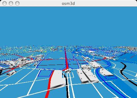
Osm3d v.0.02
This is Osm3d - a software to display 'Open Street Map' data in 3d - for Linux and MacOS X.
AnyChart Map Converter v.1.0.3261.26913
Visualize geolocation data in ESRI ShapeFiles format. AnyChart Map Converter utility is designed to convert ESRI ShapeFiles (*.shp) into the special AMAP format for using in the geo map module of AnyChart Flash Component - AnyMap.
EdiTrail v.1.0
Create/Edit/Display/Management/Import/Export Trails/Routes in a simple and flexible environment divided in a data table for the management of trails and a map resulting from numerous providers, (Bing, Arcgis, Ovi, Yahoo, etc).
GeoVisu v.5.0.1
GeoVisu is a program that displays georeferenced data (images, graphics) and downloads data recorded by some GPS devices. GeoVisu has a 'Moving map' navigation function, which can be used with any NMEA 0183 compatible or Garmin USB GPS device.